Tai Po
Koordinatlar: 22°27′03″K 114°09′51″D / 22.45083°K 114.16417°D
| Tai Po 大埔區 |
|
| — Semt — | |
| Tai Po semti | |
 Tai Po New Town |
|
 |
|
| Koordinatlar: 22°27′03″K 114°09′51″D / 22.45083°K 114.16417°D | |
| Ülke | |
|---|---|
| Bölge | Yeni Bölgeler |
| Yönetim | |
| - Semt başkanı | Bassanio So |
| Yüzölçümü | |
| - Toplam | 148,05 km2 (57,2 mi2) |
| Nüfus (2006)[1] | |
| - Toplam | 293.542 |
| - Yoğunluk | 2.000/km² (5.180/sq mi) |
| Zaman dilimi | HKT (+8) |
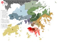
Tai Po (Çince: 大埔區), Hong Kong'un 18 semtinden biridir. Semt, Yeni Bölgeler'de yer almaktadır. Yüzölçümü 148.05 km² olan semtin nüfusu 2006 yılı ile 293,542'dir.[1]
Kaynakça
- 1 2 "Hong Kong Statistics – Population by District Council District, 1996, 2001 and 2006". Hong Kong Census and Statistics Department. http://www.censtatd.gov.hk/hong_kong_statistics/statistical_tables/index.jsp?tableID=141&ID=&subjectID=1. Erişim tarihi: 14 Mayıs 2016.
Dış bağlantılar
| ||||||||||||||||
This article is issued from Vikipedi - version of the 5/14/2016. The text is available under the Creative Commons Attribution/Share Alike but additional terms may apply for the media files.
